|
| |
Remonter
Carte
géographiques des voyages de Joseph Landry
Explorateur
accompagnant Alexander MacKenzie
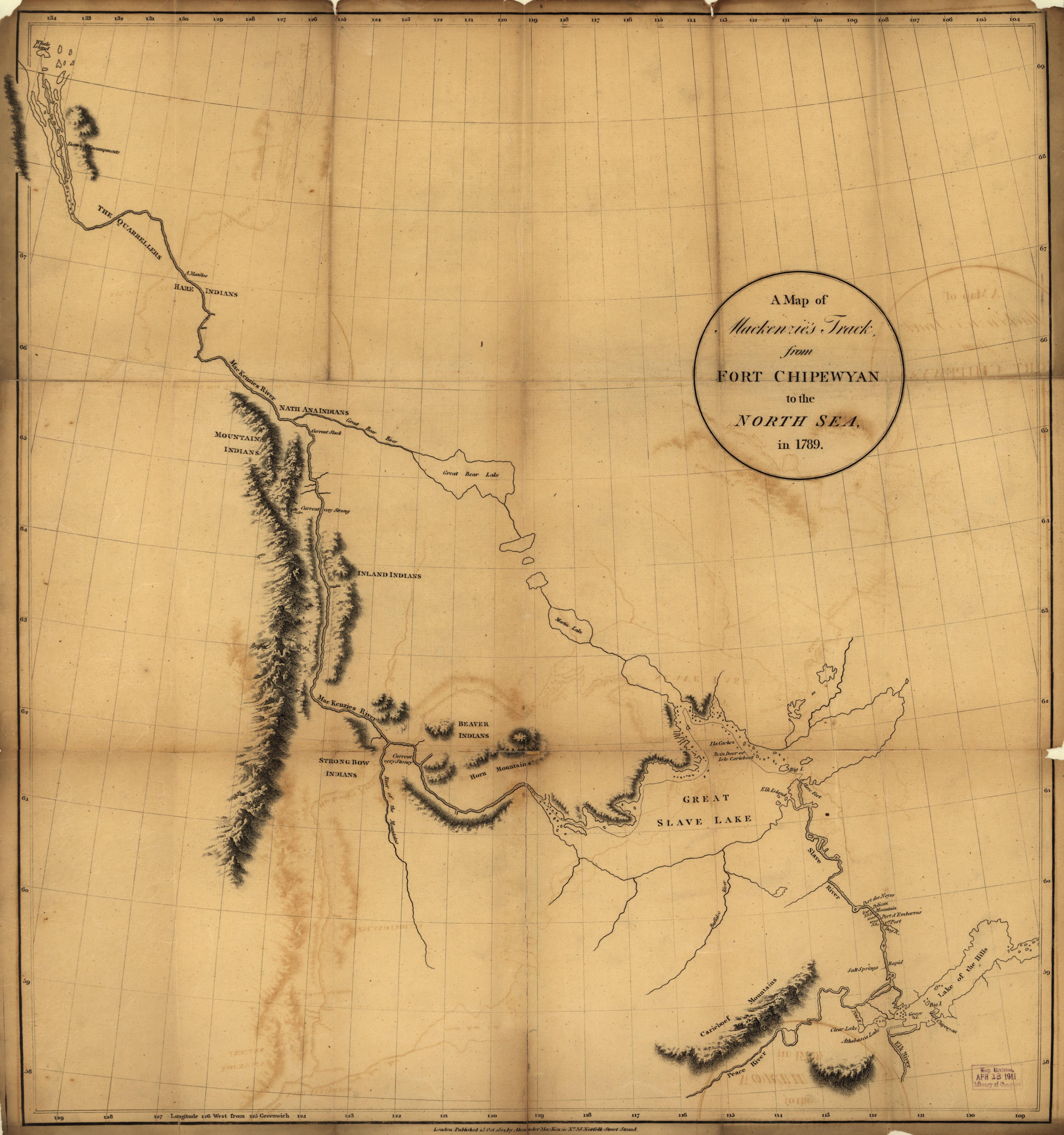
Carte du voyage de 1789 vers la Mer du Nord -
Visionner en pleine grandeur
5676*6059 pixels. Attention 4,18 MegOctets
Source.
|
Fichier: ct000690.jp2
Source: Geography and Map Division, Library of Congress
Pour usage éducatif et sans droit d'auteur selon la source :
A map of Mackenzie's track from Fort Chipewyan to the north sea in 1789.
Mackenzie, Alexander, 1763-1820.
CREATED/PUBLISHED - London : Published by Alexander MacKenzie, 1801.
NOTES "... Published 15 Oct. 1801 ..."
Relief shown by hachures.
Scale [ca. 1:2,300,000] (W 1340--W 1040/N 700--N 580).
SUBJECTS Canada, Western--Discovery and exploration--Maps. Canada, Western.
MEDIUM 1 map ; 59 x 55 cm.
CALL NUMBER G3466.S12 1801 .M2 Vault
REPOSITORY Library of Congress Geography and Map Division Washington, D.C.
20540-4650 USA
DIGITAL ID g3466s ct000690
https://hdl.loc.gov/loc.gmd/g3466s.ct000690
|
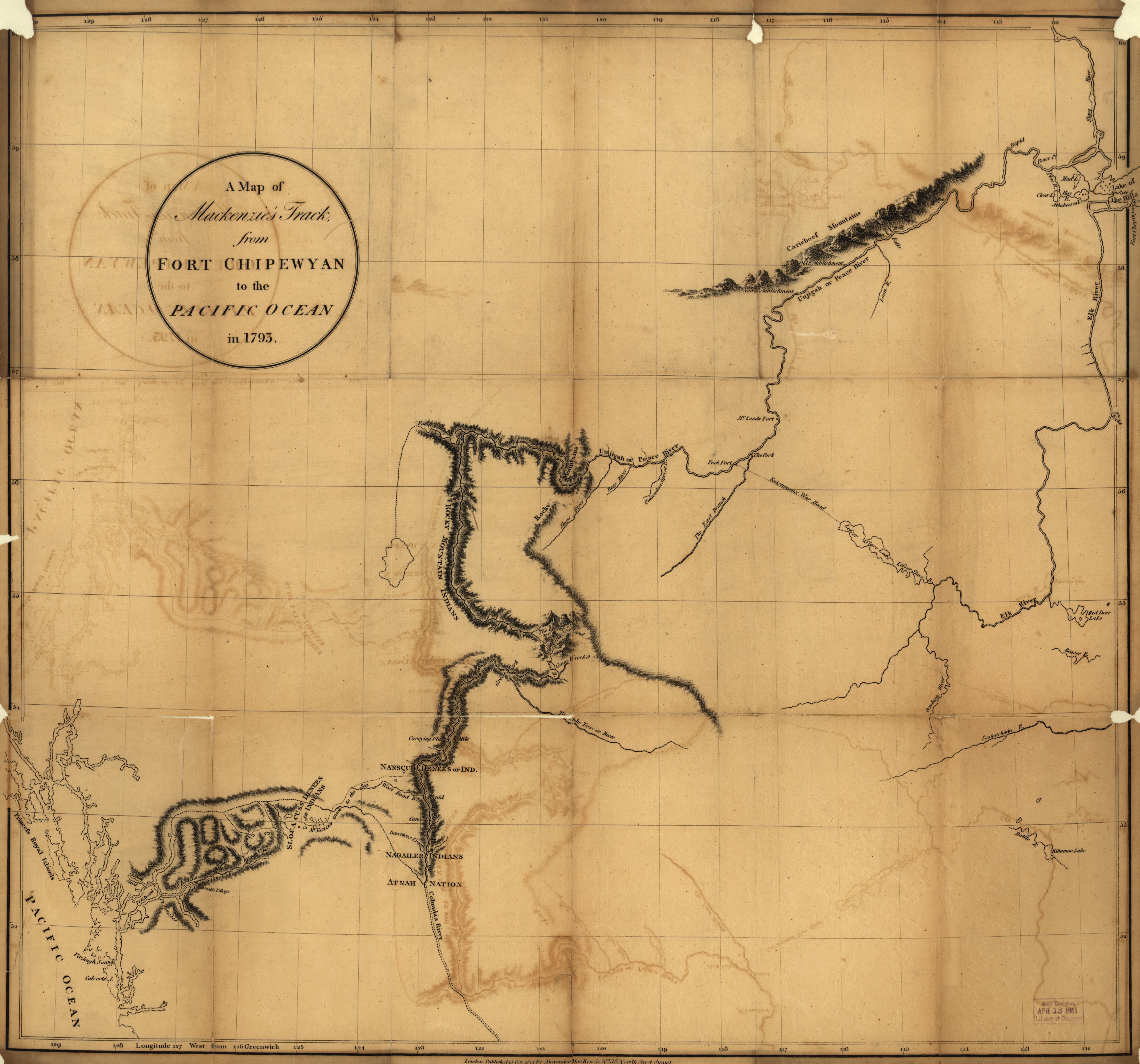
Carte du voyage de 1793 de Fort Chipewan et l'océan Pacifique
- Visionner en pleine
grandeur 6056*5651 pixels.
Attention 4,18
MegOctets
Source.
|
Fichier: ct000691.jp2
Source: Geography and Map Division, Library of Congress
Pour usage éducatif et sans droit d'auteur selon la source
A map of Mackenzie's track from Fort Chipewyan to the Pacific Ocean in 1793.
Mackenzie, Alexander, 1763-1820.
CREATED/PUBLISHED - London : Published by Alexander MacKenzie, 1801.
NOTES - "... Published 15 Oct. 1801 ..."
Relief shown by hachures.
Scale [ca. 1:1,850,000] (W 1300--W 1110/N 600--N 510).
SUBJECTS Canada, Western--Discovery and exploration--Maps. Canada, Western.
MEDIUM - 1 map ; 55 x 61 cm.
CALL NUMBER - G3466.S12 1801 .M21 Vault
REPOSITORY - Library of Congress Geography and Map Division Washington, D.C.
20540-4650 USA
DIGITAL ID - g3466s ct000691
https://hdl.loc.gov/loc.gmd/g3466s.ct000691
|
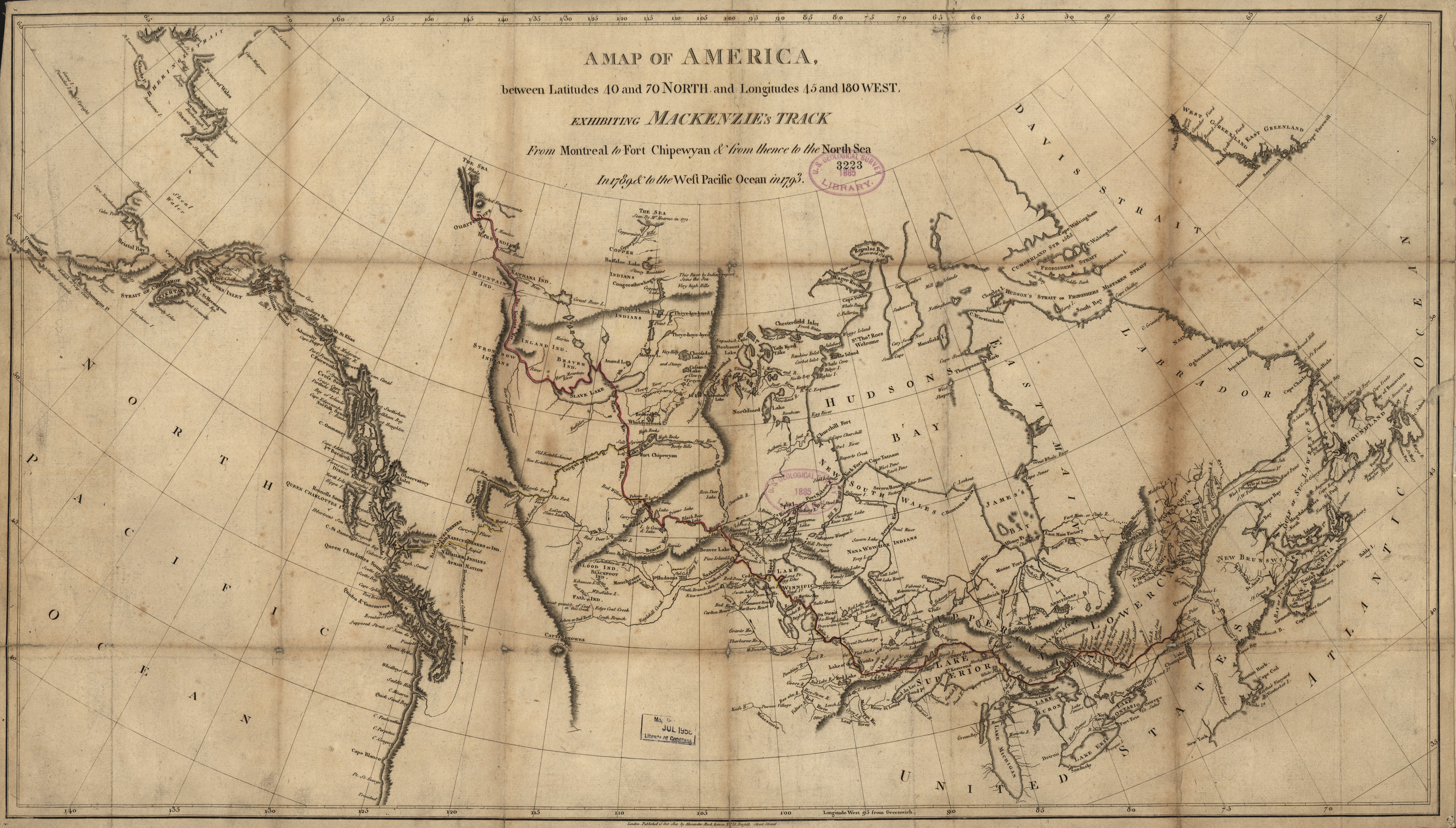
Carte du voyage à partir de Montréal vers fort Chipewan et de là
en 1789 vers la Mer du Nord et en 1793 vers le Pacifique
-
Visionner en pleine grandeur 7838*4460 pixels.
Attention 6,07,18
MegOctets
Source.
|
Fichier: ct000692.jp2
Localisation de la carte:
https://memory.loc.gov/cgi-bin/query/D?gmd:12:./temp/~ammem_9jKZ::
Source: Geography and Map Division, Library of Congress (
https://memory.loc.gov/ammem/gmdhtml/dsxphome.html)
Pour usage éducatif et sans droit d'auteur selon la source :
https://memory.loc.gov/cgi-bin/ammemrr.pl?title=%3Ca%20href%3d%22%2fammem%2fgmdhtml%2fgmdhome.html%22%3EMap%20Collections%3C%2fa%3E&coll=gmd&div=&agg=g3401s&default=ammem&dir=ammem
A map of America between latitudes 40 and 70 north and longitudes 45 and 180
west exhibiting Mackenzie's track from Montreal to Fort Chipewyan & from
thence to the north sea in 1789 & to the west Pacific Ocean in 1793.
Mackenzie, Alexander, 1763-1820.
CREATED/PUBLISHED London : Published by Alexander Mack Kenzie, 1801.
NOTES "... Published 15 Oct. 1801 ..."
Relief shown by hachures.
Scale [ca. 1:9,250,000] (W 1700--W 350/N 700--N 350).
SUBJECTS Canada--Discovery and exploration--Maps. Canada.
MEDIUM 1 map : hand col. ; 43 x 78 cm.
CALL NUMBER G3401.S12 1801 .M2 Vault
REPOSITORY Library of Congress Geography and Map Division Washington, D.C.
20540-4650 USA
DIGITAL ID g3401s ct000692
https://hdl.loc.gov/loc.gmd/g3401s.ct000692 |
| Aussi disponible aux Archives nationales du Québec Titre
: A Map of America between latitudes... exhibiting Mackenzie's track from
Montréal to Fort Chipewyan & from thence to the North Sea in 1789 & to the
West Pacific Ocean in 1793
Date de publication : 1801 (9)
Auteur : Mackenzie, Alexander, 1764-1820
Éditeur : London : the author
Description : 1 carte : coul. ; 44 x 78 cm
Lieu : Canada (60)
Localisation de l'original : Bibliothèque et Archives nationales du Québec
Cote : G 3400 1801 M3 CAR
Numéro catalogue Iris : 0002662971 |
Marcel Walter Landry - Pour toute question ou problème concernant ce site Web,
envoyez moi un courriel.
Dernière modification
: samedi 08 novembre 2025
|